Summary of Meeting:
The Arkansas Department of Agriculture Natural Resources Division (NRD) and the Oklahoma Conservation Commission (OCC) jointly held a stakeholder meeting as part of updating watershed management plans for the Illinois River watershed. The meeting was held in the afternoon in West Siloam Springs, OK (Cherokee Hotel and Casino). A total of 96 individualsattended the meeting, 81 in person and 15 online. Attendees included landowners and business owners, as well as individuals from interest groups, and employees from state and federal agencies. A list of specific organizations represented at the meetings is included as Attachment 1.
The meeting was facilitated by Tate Wentz, NRD, Water Quality Section Manager. The agenda for the meeting is shown on page 1 of Attachment 2. The meeting was also presented and recorded using Zoom. The recording of the meeting can be viewed on the OCC YouTube site:
https://www.youtube.com/@oklahomaconservationcommis9356/videos. A copy of all the presentations from this meeting is provided in Attachment 2.
Tate Wentz opened the meeting thanking everyone for attending and identifying team members present from NRD, their contractor FTN Associates, and OCC. He then went over the agenda and purpose for the meeting. Following this, Mr. Wentz presented basic information on watershed management plans and the process for updating the plans for the Illinois River watershed, along with the benefits of having watershed management plans. Mr. Wentz then summarized information from the first two public meetings, and a proposed time and purpose for the next public meeting. Mr. Wentz then turned the podium over to Greg Kloxin of OCC.
Mr. Kloxin started by asking how many of those present were attending an Illinois River public meeting for the first time. Around one third of those present raised their hand. Mr. Kloxin then stated that this effort is the result of a long collaboration between Arkansas, Oklahoma, the Cherokee Nation, the US Environmental Protection Agency (EPA). He stated that the waterquality models that will be presented today are intended to be tools to assist with decision making about non-regulatory management of nonpoint sources of pollution. The models will inform the update of the watershed management plans, which will be combined to create the Watershed Implementation Plan for the Illinois River. Mr. Kloxin stressed that Arkansas and Oklahoma are collaborating in the preparation of the models and the update of the watershed management plans, freely sharing information and data.
Mr. Kloxin explained that all water quality models attempt to emulate reality, but none do so perfectly. He used Google Maps, which is a computer model, as an example of how models can do a good job of representing reality, but they aren’t always perfect. Most people have had an experience where Google Maps did not easily get them where they wanted to go. Mr. Kloxin explained that a model’s representation of reality depends on data. When Google Maps doesn’t have the most up to date data, it does not adequately represent reality, whether that is the best road to get you where you want to go, or showing a traffic slowdown that has already cleared.
The Soil and Water Assessment Tool (SWAT) model being used for the Illinois River watershed has been used in Arkansas and Oklahoma for years, and in multiple watersheds (SWAT has been used in the past by both NRD and OCC to model the Illinois River watershed). It has strong capabilities for modeling nonpoint source pollution, particularly from agricultural sources. SWAT is used worldwide, and by many academic institutions. Texas A&M University is the repository of the SWAT model and continually works to improve the model capabilities, usefulness, and accessibility.
NRD has contracted FTN Associates (FTN) to update the SWAT model of the portion of the Illinois River watershed in Arkansas. OCC has contracted with Texas A&M to prepare a new SWAT model of the entire Illinois River watershed. Mr. Kloxin stated that the results that will be presented today are preliminary and represent baseline (current) conditions. He stressed thatmodels are not considered final, and there will be additional evaluation of model input and results before the models are finalized. When finalized, the SWAT models will be used to prioritize areas in the watershed for management and evaluate the impact of management practices.
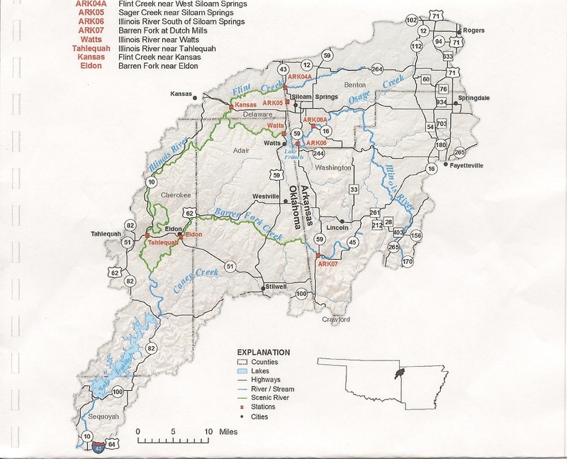
Following Mr. Kloxin, Philip Massirer of FTN presented the Arkansas SWAT model (presentation provided in Attachment 2). Mr. Massirer explained that the SWAT model simulates hydrologic and water quality processes, essentially tracking the path of water that enters the watershed as rainfall through the watershed, and associated water quality changes. The models simulate a long timeframe and represent conditions at a sub-watershed scale, i.e., conditions at individual pastures or streambanks or lawns are not represented in the models. The SWAT models are set up to report conditions in 12-digit Hydrologic Unit Code (HUC12) sub- watersheds. The SWAT model refers to these as subbasins. Within each model subbasin, Hydrologic Response Units (HRUs) are defined based on unique combinations of land cover soil series, and slope range. HRUs are the smallest unit in which activities and processes are modeled in SWAT.
There are 28 HUC12 sub-watersheds with at least 50% of their area in Arkansas. These are the sub-watersheds that are the focus of the Arkansas model. In the Arkansas model, some of thesesub-watersheds are further split into subbasins where water quality or flow monitoring stations are located. Mr. Massirer presented maps showing the Illinois River HUC12 sub-watersheds in Arkansas, the location of monitoring stations whose data was used to calibrate the model, the model subbasins, and model HRUs in the Arkansas model. The Arkansas model simulates the period 1990 through 2020, with 1996 through 2020 used for calibration. Mr. Massirer went through the input data used in the model and the sources of the input data. Inputs include daily weather (temperature, precipitation, dewpoint temperature, and wind speed), land use (2019 National Lan d Cover Database), soils data, and permitted point source discharges (12 in the Arkansas model).
 Note: this page is under construction. Summaries of previous public meetings are available on this site - See Resources.